Exploratory borehole no. 2, Thomas HillAt 8 a.m. Monday, I meet Bill O’Dowd in a hotel lobby in St. Louis, Missouri. We load up the GeoEngineers’ pickup truck and head west on Interstate 70. In St. Charles, we cross the Missouri River for the first time and parallel the river all the way to Columbia. The course of the Missouri River generally defines the southern limit of continental glaciation during the Pleistocene period. The ancestral Missouri River drained the massive melt water that resulted as the climate warmed at the end of the glacial episode, cutting its channel in the current location and developing a floodplain that is miles wide in places. Consequently, areas north of the Missouri River were buried under massive sheets of ice. These areas are now covered with glacial material and form the Dissected Till Plains of northern Missouri. Areas south of the Missouri River escaped glaciation and retain the older hills and valleys of the Ozark Highlands. Just east of Columbia, we note that the cooling tower of Callaway Nuclear Power Plant is visible in the distance. Callaway is the only nuclear power plant in the state and, together with the 16 coal-fired power plants operated by Missouri Carbon Sequestration Project member utilities, provides the vast majority of electricity used by Missouri’s farms, families and businesses.
At Columbia, we turn north onto US Highway 63 and into the heart of the Dissected Till Plain. Hills become more rounded and forests give way to farmland. At Moberly, we turn west onto Highway 24 and find our way to Associated Electric’s Thomas Hill Energy Center. Thomas Hill is the location of Exploratory Borehole No. 2, one of four deep boreholes being drilled in the state to determine the feasibility of storing carbon dioxide deep beneath Missouri power plant sites. The geologic formation of interest at Thomas Hill—and at the other borehole sites—is the Lamotte Sandstone, a beach sand that formed on top of the barren Pre-Cambrian granites, rhyolites and diorites as a shallow sea rose to cover the region eons ago. As sea level rose even higher, sediment was washed into the sea from the surrounding land masses and settled on top of the sand layer to form an impermeable shale layer—forming the perfect trap for carbon dioxide.

The Thomas Hill borehole has been drilled and cored to a depth of 2,500 feet, and geophysical logging completed. The Lamotte Sandstone was encountered at a depth of 2,333 feet and Pre-Cambrian basement rock encountered at a depth of 2,530 feet. The borehole is now capped, awaiting additional geophysical logging by the Division of Geology and Land Survey and possible pressure testing and fracture testing. Once all work has been completed the borehole will be grouted and abandoned, but will leave behind a wealth of new information on Missouri geology.
Thomas Hill was a “mine mouth” power plant—burning Missouri coal mined at the site—until tightening air regulations prompted Associated Electric to close the mines and switch to lower-sulfur, Wyoming coal in the early 1990s. After inspection of the drilling site and a very productive discussion with Kim Dickerson, Principal Environmental Coordinator at Thomas Hill, we resume our journey across Missouri and head north toward US Highway 36. We turn onto Highway 36 at Bevier, a former coal mining town that is the namesake of the Bevier-Wheeler coal seam mined at Thomas Hill. As it is well past lunchtime by this time and we are both very hungry, we start looking for a place to eat. We soon learn that Highway 36 is largely a rural highway in this area with few towns along our route. Sixty miles later we arrive at Applebee’s in Chillicothe to our great relief (Note to self: for the next trip along Highway 36, pack a lunch).
From Chillicothe, we continue west on Highway 36 across the till plains. Along the way, we note a number of very broad floodplains that appear to contain one or two undersized streams. We make a note to review maps when we return to the office to determine the geomorphology of these features. We continue westward (shades of Horace Greeley) to St. Joseph, the former home of the fastest four-legged mail service in history – the Pony Express. For a brief 19 months, riders carried the mail from St. Joseph to Sacramento—a distance of approximately 2,000 miles—in 10 days. Although this was an extraordinary feat, the service was very soon supplanted by transcontinental telegraph lines and the transcontinental railroad.
From St. Joseph, we proceed south on Interstate 29 to Platte City, and on to Weston. On the drive between Platte City and Weston, we pass picturesque country estates with neatly manicured fields and gleaming white fences. We also note that the farm fields are plowed up and down the slope, a practice that would result in severe erosion in southern Missouri (fields have to be plowed perpendicular to the ground slope). This practice is possible in northern Missouri due to the thick mantle of loess – windblown glacial silt that readily drains water and can stand in vertical cuts.
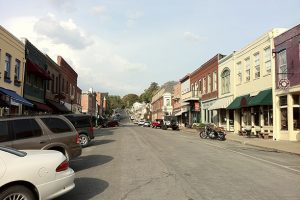
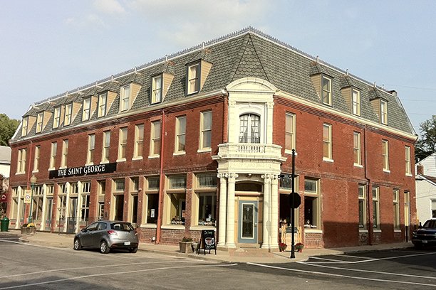
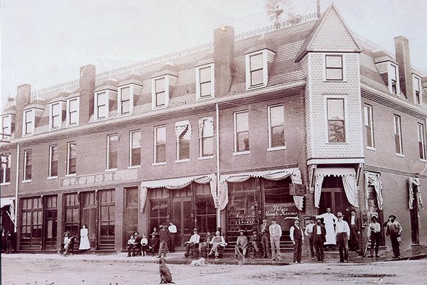
Weston, founded in 1837, once had the distinction of being the westernmost town in the United States. In the 1800s, Weston was a thriving river town. By 1849, Weston had become the steamboat capitol of the west, servicing 224 steamboats and serving as a major port for tobacco and hemp. In 1881, however, major flooding shifted the Missouri River channel one mile to the west into Kansas and marked the decline of Weston as a river port. The Weston of today is a weekend and vacation destination featuring a number of restaurants, shops and bed and breakfast establishments. Our 350-mile Day 1 journey ends at the Saint George Hotel and a much-awaited dinner at Weston Brewing Company. Early tomorrow morning, we will tour Kansas City Power & Light’s Iatan Electric Generating Station, the site of Exploratory Borehole No. 4.