At 8 a.m., Bill O’Dowd and I pull into the Havener Student Center parking lot and walk across the street to McNutt Hall, the home of all Geosciences at Missouri University of Science & Technology. Dave Wronkiewicz shows up a few minutes later, and we begin our tour of MS&T laboratory facilities to review the carbon sequestration research underway. Dr. Shari Dunn-Norman and Steve Bodenhamer arrive at McNutt and join us at stops along the way.
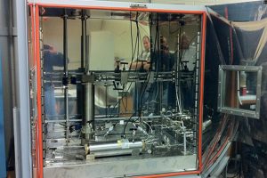
One of the first stops is to view an experiment involving pressure chambers containing rock core. The pressure chambers are used to characterize the changes in geochemistry that occur when carbon dioxide is injected into a reservoir rock, such as the Lamotte Sandstone. As carbon dioxide moves through the rock, some minerals dissolve and other minerals form. Since increases in temperature generally increase the speed of chemical reactions, the experiments are conducted at high temperature to simulate sequestration of carbon dioxide over thousands of years. In this case, carbon dioxide is injected into the chamber, which contains rock core and a brine solution.
Along the way we also inspect MS&T’s core flooding apparatus. This equipment can be configured to quantify parameters such as liquid permeability, water flood, water flood susceptibility and gas/liquid relative permeability. Core flooding is a very useful test to determine rock permeability, and how well various fluids, including carbon dioxide, will flow through it. MS&T also has research underway to determine geomechanical properties of the rock formations. At the end of our meeting, Dr. Wronkiewicz and Dr. Dunn-Norman head off to teach classes and assist with the many personal problems of freshman engineering students; and Bill O’Dowd, Steve Bodenhamer and I head to McCracken Core Library to inspect rock core from Exploratory Boreholes 1 and 2.
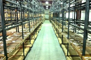
McCracken Core Library and Research Center is not a library in the normal sense, but, rather, a large warehouse that houses racks and racks of rock core. The 21,000 square foot facility serves as a repository for more than 2.5 million linear feet of exploration rock core that has been donated to the State of Missouri. The McCracken Core Library and Research Center is one of the largest such collections in the nation and is open by appointment only. Study and examination rooms are available for use by researchers. The core comes from landfills, quarries and hazardous waste sites, as well as highway department construction, and oil, gas and mineral exploration drilling in Missouri. The rock core generated by the four Missouri Carbon Sequestration Project boreholes will add significantly to the collection of very deep core housed in the facility, and will be used by researchers for years to come—possibly by some of Shari Dunn-Norman’s freshman engineering students.
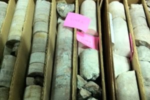
At McCracken, we meet Chris Vierrether, Larry “Boot” Pierce and Patrick Scheel of DGLS. The core from the two boreholes has been retrieved from storage and laid out for our inspection ahead of time. We walk along the racks of core, inspecting each segment and pointing out significant features to Mr. O’Dowd. The confining layer (an impermeable rock layer that lies above the storage layer and holds the carbon dioxide in place) in both boreholes is the Davis Formation, a shale layer, which contains flat limestone pebbles and looks much like a zebra. Our testing, to date, has shown the Davis Formation to be extremely tight. The target formation in both boreholes is the Lamotte Sandstone, which can vary significantly from one location to the next. Imagine, if you will, a long walk along the beach. You will find areas where the sand is very clean and uniform, areas where the sand is mixed with gravel, and areas where the sand is dirty. Likewise, there are different “depositional environments” where the Lamotte Sandstone formed. At the John Twitty Energy Center borehole in Springfield, the sand grains in the Lamotte were found to be very well cemented together, with very little pore space and very low permeability. Lamotte core from the Thomas Hill site has yet to be tested, but visual inspection suggests it will be much more porous and permeable than the Springfield core (so far, so good).
Following the inspection of McCracken core, it’s “back in the truck, another tank of gas, and off to the Luecke drilling site in St. Louis.” We arrive at the Luecke Site mid-afternoon. The Luecke borehole is officially the Ameren Missouri-Sioux Power Plant borehole. Since there were no available drilling sites at the Sioux property, which is located in the floodplain between the Mississippi and Missouri Rivers, the borehole is being drilled on leased property at the former Bellfontaine Quarry site, located up out of the floodplain and a couple of miles south of the power plant. The drilling site is located at a large bend in the Missouri River, and directly adjacent to the Car of Commerce Chute. Geologically, the chute is a meander cutoff, which provides a shortcut for river water at higher flows. The chute received its name from a steamboat that blew up and sank at that location in 1828.
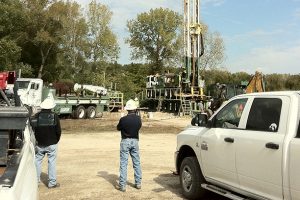
Layne Christensen, our drilling contractor, had commenced drilling operations earlier that afternoon and had progressed to a depth of approximately 20 feet by the time we arrived on site. Conductor pipe will be installed and cemented into the shallow bedrock, and then rotary drilling will continue to the top of the confining layer, anticipated at a depth of 2,850 feet. At that point, the drilling rig will be replaced by a coring rig, and coring will continue through the confining layer and target formation to the Pre-Cambrian surface, anticipated at a depth of 3,220 feet. The core from this borehole will also be transferred to McCracken Core Library, and samples of core will be provided to Missouri State University and Missouri University of Science & Technology for continuing research on this project.
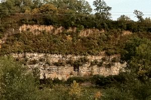
Following our site inspection and observation of drilling operations, as we leave the Luecke site we note a vertical wall of loess above the limestone quarry face on the far side of the quarry, confirming that we are now back in the Dissected Till Plains physiographic region. I drop Bill O’Dowd at the Marriott St. Louis International Airport and head back toward the Springfield Plateau and the Springfield Office.
I conferred honorary Missouri citizenship on Mr. O’Dowd before he headed home to Pittsburgh, since in three days he had seen more of the state than many citizens. My total distance driven, from leaving the Springfield Office on Sunday, September 30 to returning to the Springfield Office on Thursday, October 4 was 1,374 miles–all within the state boundaries.
